National Parks Atlas
To the park
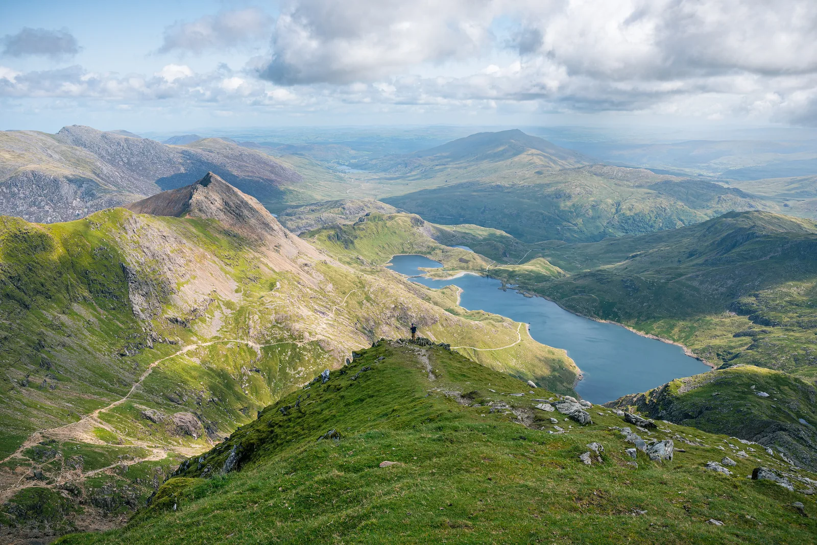
View from near the summit of Snowdon (Yr Wyddfa) in Snowdonia National Park down to the lake Llyn Llydaw, with the Crib Goch ridge on the left

Snowdonia National Park (Eryri): map

15 places with verified coordinates · 3 with photo

Bookable in the park · 3

Ad · partner links: we may earn a commission if you book – at no extra cost to you. Thank you for supporting the atlas. Offer details checked 8 Oct 2026; dates and prices with the provider.

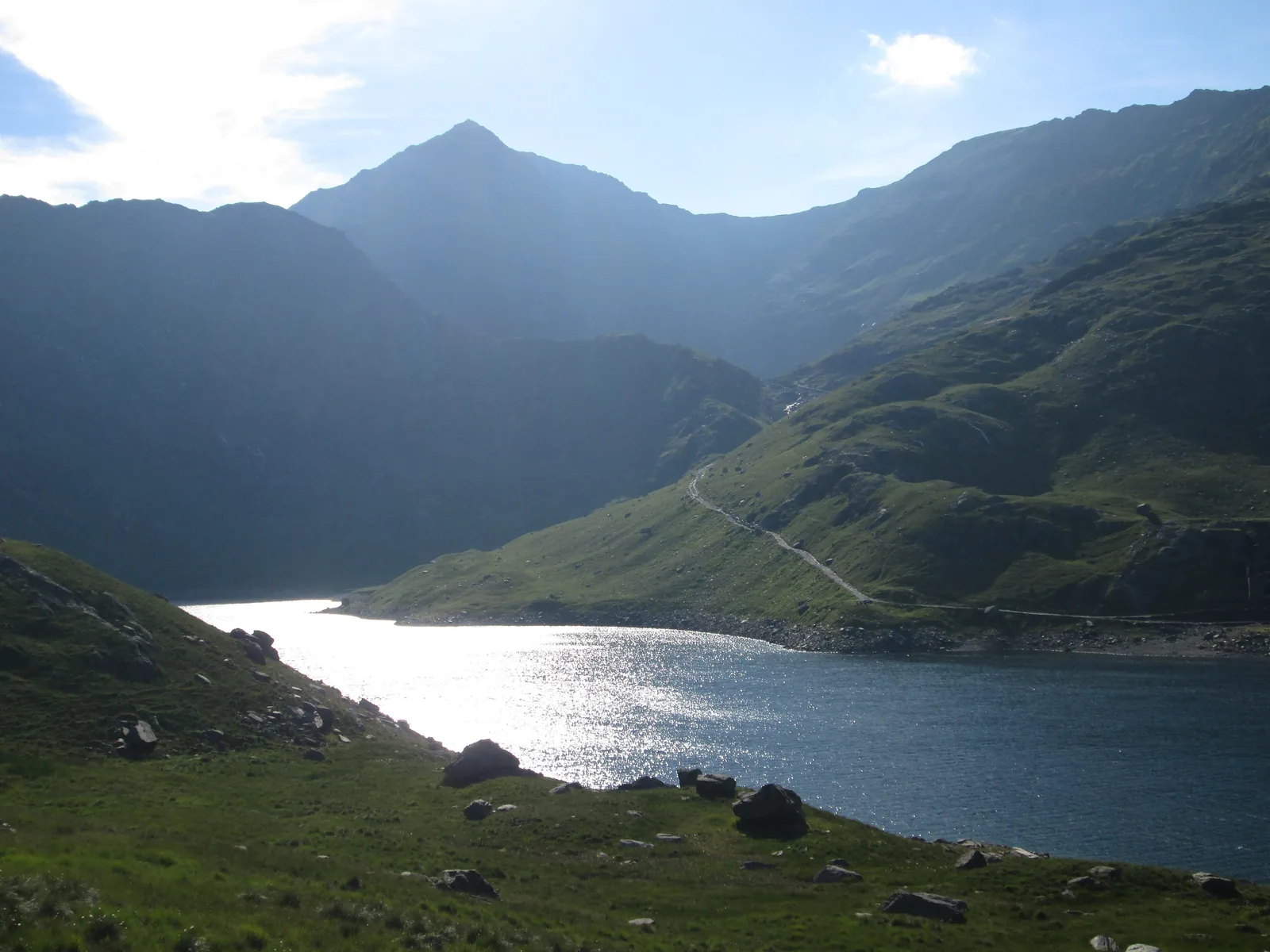
The lake Llyn Llydaw in Snowdonia National Park against the light, with the pointed summit of Snowdon (Yr Wyddfa) above
Photo: Peter S ↗ · CC BY-SA 2.0 ↗

Mountains & rock · Highest mountain in Wales, 1,085 m (3,560 ft)

Yr Wyddfa (Snowdon)

Six paths lead up; often crowded in summer.

The highest mountain in Wales – and one of the busiest in Britain.

Height
1,085 m (3,560 ft)
Paths
6, each 11–14.5 km
Visitors
over 600,000 a year
Summit building
Hafod Eryri

Own page

Snowdon (Yr Wyddfa)

The highest mountain in Wales – six paths, a rack railway and, on summer days, a great many people.

Costs on Snowdon 2026
Pen y Pass car park, up to 8 / 12 hours / full day (pre-booking only)25 £ / 35 £ / 45 £
Railway diesel service, adult, return to the summit (off-peak / peak)45 £ / 48 £
Railway diesel service, adult, return to Clogwyn (off-peak / peak)36 £ / 39 £

Paths & getting there

Things to do: six paths up Snowdon, Ogwen and lakes

Six paths up Snowdon

Llanberis Path 14.5 km, Miners’ Track 13 km, Pyg Track 11 km, Watkin Path 13 km, Rhyd Ddu Path 12 km, Snowdon Ranger 13 km – each there and back, all hard, 6 to 7 hours.

Eryri National Park Authority: Climbing Yr Wyddfa (six paths, equipment, emergencies) ↗

Guided from here · Ad

Partner links: we may earn a commission if you book – at no extra cost to you. Thank you for supporting the atlas. Dates and prices with the provider.

Open in OpenStreetMap ↗Location source ↗

53.06849, -4.07623

Mountains & rock · Summit building with café, terminus of the railway

Hafod Eryri

Run by the mountain railway, not by the National Park Authority.

Own page

Snowdon (Yr Wyddfa)

The highest mountain in Wales – six paths, a rack railway and, on summer days, a great many people.

Paths & getting there

Open in OpenStreetMap ↗Location source ↗

53.06815, -4.07675

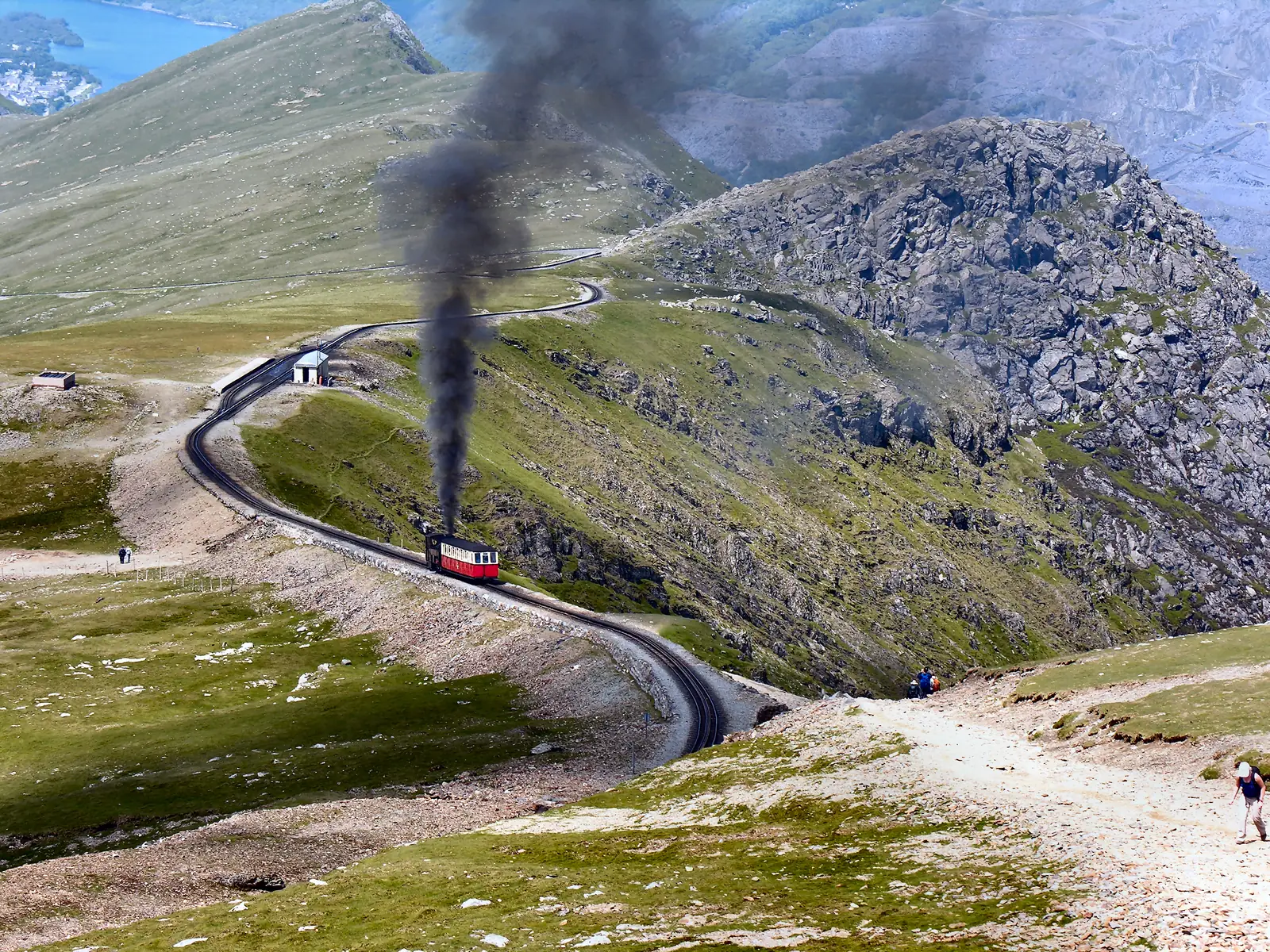
A steam train of the Snowdon Mountain Railway at Clogwyn station in Snowdonia National Park, the mountainside behind
Photo: Denis Egan ↗ · CC BY 2.0 ↗

Mountains & rock · Base station of the mountain railway

Llanberis (Snowdon Mountain Railway)

The rack railway has run from here to the summit since 1896.

By rack railway to the summit since 1896.

Distance
4.7 miles
Start
Llanberis
Season 2026
until 1 November
Operator
private

Own page

Snowdon (Yr Wyddfa)

The highest mountain in Wales – six paths, a rack railway and, on summer days, a great many people.

Paths & getting there

Free entry – parking, railway and bus cost money

Railway: from £45 to the summit

The Snowdon Mountain Railway is a private company. A return on the diesel train to the summit costs adults £45 off-peak and £48 at peak times in 2026; to Clogwyn station £36 and £39.

Snowdon Mountain Railway: Times and prices 2026 (operator, operating times and fares) ↗

Things to do: six paths up Snowdon, Ogwen and lakes

Rack railway since 1896

The Snowdon Mountain Railway runs 4.7 miles from Llanberis to the summit building Hafod Eryri. If you walk up, you can only buy a ticket down at the top, subject to availability.

Snowdon Mountain Railway: Times and prices 2026 (operator, operating times and fares) ↗

Guided from here · Ad

Partner links: we may earn a commission if you book – at no extra cost to you. Thank you for supporting the atlas. Dates and prices with the provider.

Open in OpenStreetMap ↗Location source ↗

53.11629, -4.11968

Arrival · Car park, start of the Pyg Track and Miners’ Track

Pen y Pass

Pre-booking only until 1 November 2026; the Sherpa bus stops here.

Own page

Snowdon (Yr Wyddfa)

The highest mountain in Wales – six paths, a rack railway and, on summer days, a great many people.

Paths & getting there

Free entry – parking, railway and bus cost money

Pen y Pass: £25 to £45

The National Park Authority’s car park at the start of the Pyg Track and Miners’ Track can only be used with a JustPark booking until 1 November 2026: £25 up to 8 hours, £35 up to 12 hours, £45 for the full day. Extensions are not possible.

Eryri National Park Authority: Pen y Pass Car Park (pre-booking until 1 Nov 2026, charges) ↗

Open in OpenStreetMap ↗Location source ↗

53.08037, -4.02066

Surroundings · Village, car park with bus connection

Nant Peris

The Sherpa’r Wyddfa runs from here to Pen y Pass.

Own page

Snowdon (Yr Wyddfa)

The highest mountain in Wales – six paths, a rack railway and, on summer days, a great many people.

Paths & getting there

Open in OpenStreetMap ↗Location source ↗

53.10454, -4.08085

Nature · Halt, start of the Rhyd Ddu Path

Rhyd Ddu

Route S3 from Caernarfon and the Welsh Highland Railway.

Own page

Snowdon (Yr Wyddfa)

The highest mountain in Wales – six paths, a rack railway and, on summer days, a great many people.

Paths & getting there

Where to go next

Welsh Highland and Ffestiniog Railway

The National Park Authority recommends the two steam railways as a fine way to travel through the north-west of the park; the Welsh Highland Railway stops at Rhyd Ddu and Beddgelert.

Eryri National Park Authority: Getting to and around (rail, road, bus) ↗

Open in OpenStreetMap ↗Location source ↗

53.05109, -4.13304

Nature · Start of the Watkin Path

Pont Bethania

Route S4 from Porthmadog.

Own page

Snowdon (Yr Wyddfa)

The highest mountain in Wales – six paths, a rack railway and, on summer days, a great many people.

Paths & getting there

Open in OpenStreetMap ↗Location source ↗

53.03557, -4.04834

Surroundings · Village with a National Park information centre

Beddgelert

Canolfan Hebog information centre, daily 9:30 to 17:00.

Open in OpenStreetMap ↗Location source ↗

53.01177, -4.10781

Arrival · Station and village with an information centre

Betws-y-Coed

Conwy Valley Line from Llandudno Junction; circular walk over the bridges, 3.6 km.

Visiting Snowdonia (Eryri): mountains, lakes and coast

Contact: three information centres

The National Park Authority runs information centres in Betws-y-coed, Beddgelert and Aberdyfi, daily 9:30 to 17:00 with a 30-minute lunch break.

Eryri National Park Authority: Information Centres (Betws-y-coed, Beddgelert, Aberdyfi) ↗

How to get there: by rail and Sherpa bus to the trailheads

Conwy Valley Line

From north-west England by train via Crewe to Llandudno Junction, then on the Conwy Valley Line to Betws-y-Coed.

Eryri National Park Authority: Getting to and around (rail, road, bus) ↗

Things to do: six paths up Snowdon, Ogwen and lakes

Betws-y-Coed: 3.6 kilometres

An easy circular walk over the bridges of the Afon Llugwy in about 45 minutes, from the National Park Authority’s Cae Llan car park.

Eryri National Park Authority: Betws-y-coed Bridges (3.6 km circular walk) ↗

Open in OpenStreetMap ↗Location source ↗

53.09269, -3.80054

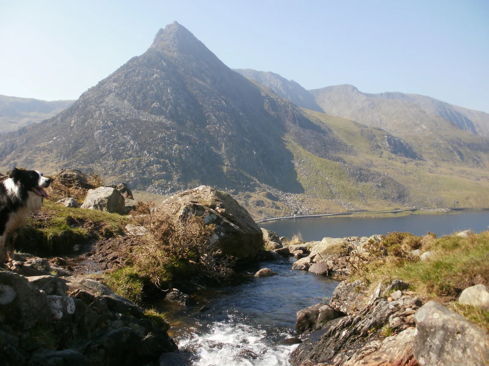
The rocky peak of Tryfan in Snowdonia National Park above the lake Llyn Ogwen, a stream between rocks in front
Photo: Peter S ↗ · CC BY-SA 2.0 ↗

Arrival · National Park car park at the Cwm Idwal Centre

Ogwen

Small car park that fills quickly; T10 bus from Bangor and Betws-y-Coed.

The glacial valley between two mountain ranges.

Parking
£6 a day, card only
Bus
TrawsCymru T10
Centre
Cwm Idwal Centre
If full
Bethesda and bus

Free entry – parking, railway and bus cost money

Ogwen: £6 a day

At the National Park Authority’s small car park at the Ogwen Centre a day costs £6 and four hours £3; card payment only.

Eryri National Park Authority: Ogwen (parking, T10 bus, Cwm Idwal) ↗

Open in OpenStreetMap ↗Location source ↗

53.12382, -4.02036

Water · Glacial lake in Cwm Idwal

Llyn Idwal

Famous for its geology.

Things to do: six paths up Snowdon, Ogwen and lakes

Ogwen and Cwm Idwal

The valley between the Carneddau and the Glyderau is the starting point for Tryfan and the glacial cwm Cwm Idwal. The Cwm Idwal Centre has an exhibition, toilets and a snack bar.

Eryri National Park Authority: Ogwen (parking, T10 bus, Cwm Idwal) ↗

Open in OpenStreetMap ↗Location source ↗

53.11556, -4.02559

Water · Lake on the Miners’ Track

Llyn Llydaw

With the causeway that carries the Miners’ Track.

Own page

Snowdon (Yr Wyddfa)

The highest mountain in Wales – six paths, a rack railway and, on summer days, a great many people.

Paths & getting there

Open in OpenStreetMap ↗Location source ↗

53.07362, -4.03838

Locations verified from the linked original sources and OpenStreetMap. The map shows no trails or park boundaries; markers do not imply that access is permitted.

Map: © OpenStreetMap contributors, OpenMapTiles, OpenFreeMap. Elevation: Terrain Tiles (Mapzen, AWS Open Data); 3DEP, GMTED2010 and SRTM courtesy of the U.S. Geological Survey; EU-DEM (Copernicus, European Union); ETOPO1 (NOAA); ArcticDEM (NSF, DigitalGlobe); Geoscience Australia; Open Data Austria (DGM); Open Government Licence – Canada; INEGI; Land Information New Zealand; Kartverket; Environment Agency (UK).

Park photo: Photo: Julian Herzog (Website) ↗ · CC BY 4.0 ↗

Loading map …