National Parks Atlas
Map

00 · Calanque in Calanques National Park · Cassis · Port-Miou · Port-Pin

Calanque d’En-Vau

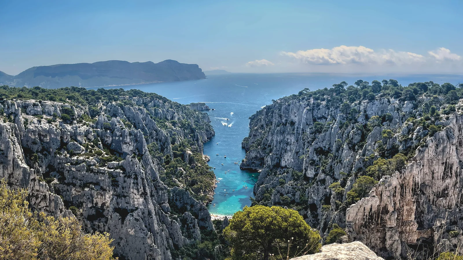
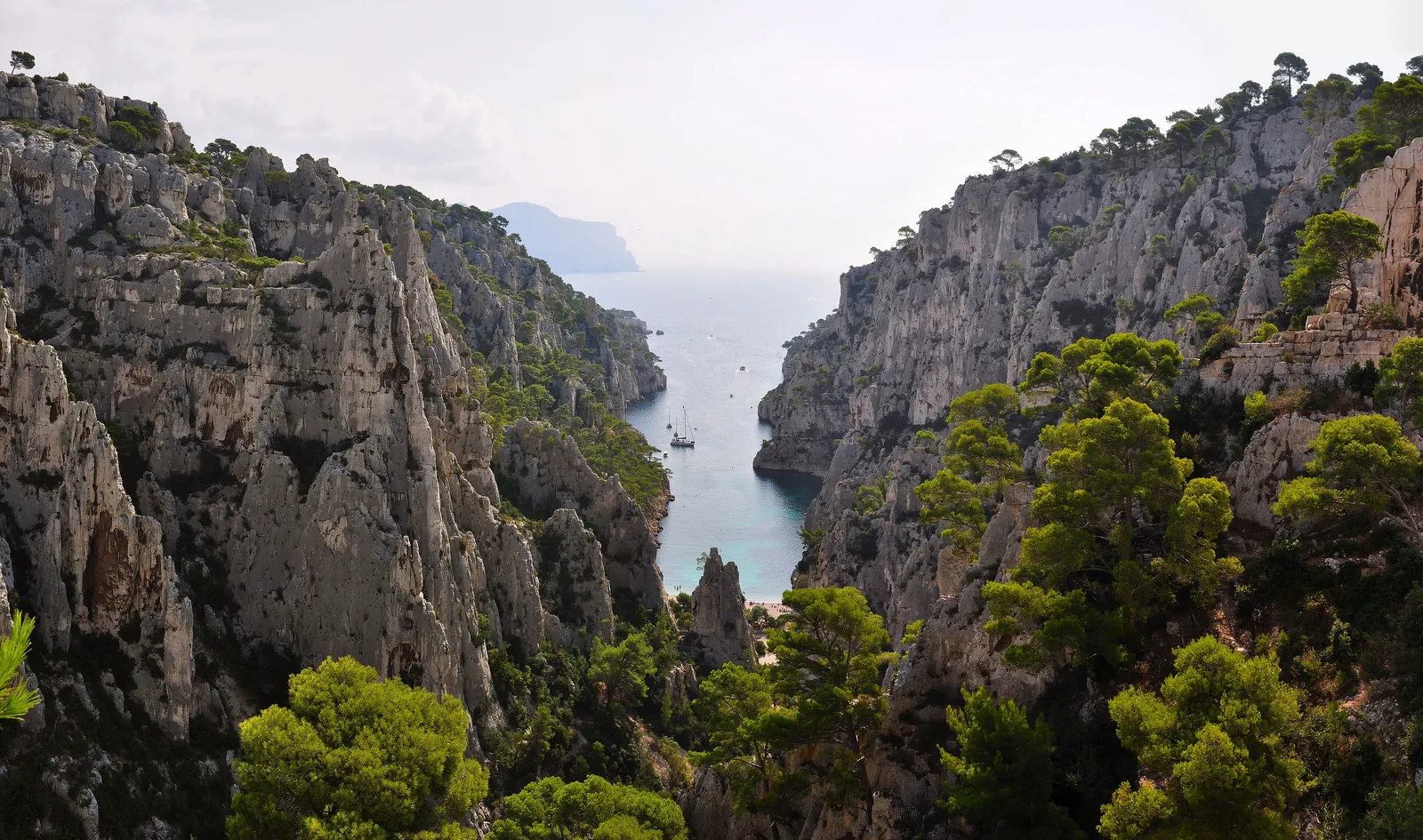
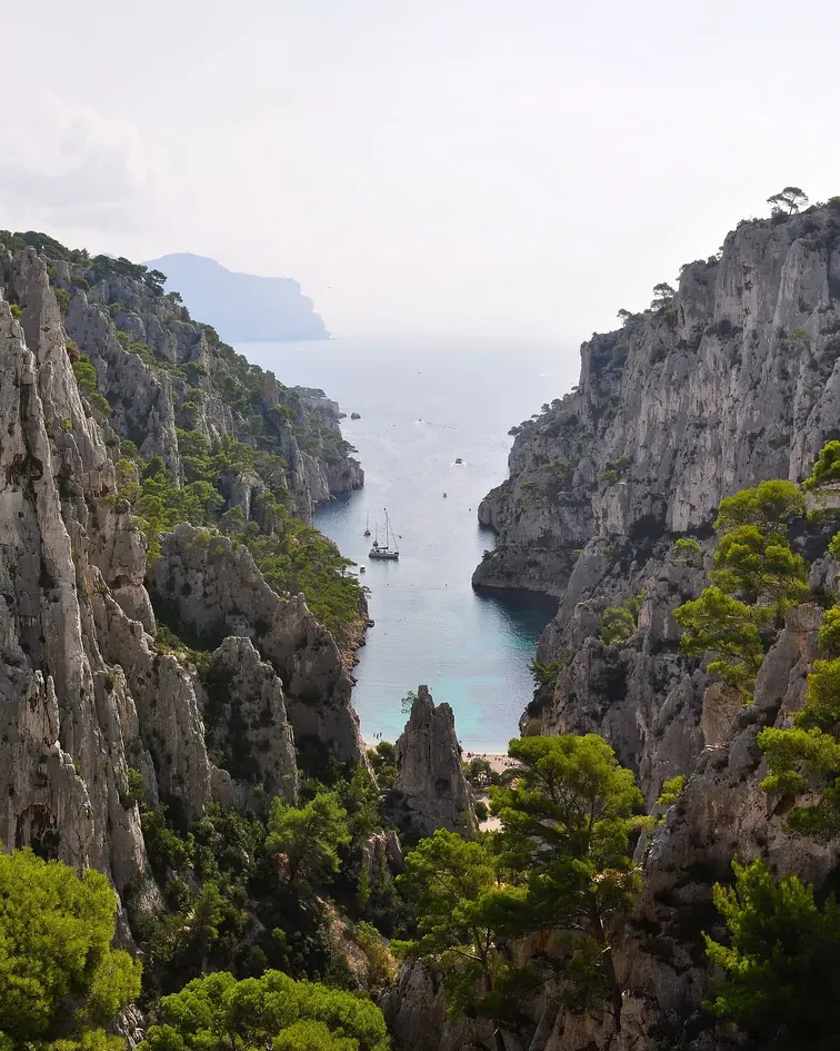
The narrowest of the Calanques: vertical limestone walls, a beach at the end and no jetty – you can only get in on foot.

Path, Belvédère & boatGetting there & parkingOpening times

View plan

Photo: Tobi 87 ↗ · CC BY-SA 3.0 ↗

freeEntrance

according to the park authority

170 m (558 ft)Belvédère

above the calanque

1.5–2 hrsFrom Cassis

on foot each way

En-Vau: the calanque “in the valley”

Reached on foot via Port-Miou and Port-Pin, via the Gardiole or from Luminy; from a boat you can only look.

The Calanque d’En-Vau lies in Calanques National Park between Marseille and Cassis. From the centre of Cassis, the park authority estimates 1.5 to 2 hours on foot; the usual route via Port-Miou and Port-Pin is 7.8 km (4.8 mi) return, three hours, 360 m (1,181 ft) of ascent, rated difficult. Landing by boat has been prohibited since the 2000s.

From the Belvédère at 170 m (558 ft) you look straight down into the cove; from there it is around an hour down via the Col de l’Oule. A blue-marked path from 2007 runs back along the coast to Port-Pin at a height of around 100 m (328 ft).

According to the park, up to 1,200 people crowd onto the beach at once in summer, in a space where 400 towels would fit comfortably. In the afternoon the calanque falls increasingly into shade. There is no drinking water, no toilets and no bins.

Parc national des Calanques: hike to the Calanque d’En-Vau via Port-Pin – 7.8 km (4.8 mi), 3 hours, 360 m (1,181 ft) (French) ↗

In numbers

Path via Port-Pin, return
7.8 km (4.8 mi)
Walking time via Port-Pin
3 hours
Ascent via Port-Pin
360 m (1,181 ft)
Path via the Gardiole
12.2 km (7.6 mi), 3 hrs
Belvédère
170 m (558 ft)
Belvédère to calanque
around 1 hour
At once in summer
up to 1,200 people
Protected since
31 July 1936

To the Calanques National Park profile

01 · Plan

Path, Belvédère & boat

By train or car to Cassis, then on foot from Port-Miou.

Photo: Tom Chirossel ↗ · CC BY-SA 4.0 ↗

Getting there and parking

By train or car to Cassis, then on foot from Port-Miou.

Price list

checked 5 Oct 2026

Entrance and costs

What the park charges – nothing – and what everything around it costs.

Calanque d’En-Vau: what a visit costs (as of 5 Oct 2026)
ItemPriceProvider
National park entrancefreeNational park
Gorguettes car park, CassisfreeTown of Cassis
Shuttle Gorguettes–Presqu’île, return€1.60Town of Cassis

According to the town of Cassis, the shuttle runs from early July to early September and on weekends in September, 9:00 to 20:00; the page gives no year. Boat trips from Cassis vary in price by tour; prices from the Bateliers association. Ville de Cassis: Gorguettes car park and shuttle to the Calanques – operating hours (French) ↗

Free entry

The national park charges no entrance fee, and neither does En-Vau. A reservation is only needed for Sugiton.

Parc national des Calanques: FAQ – free entry, open 24 hours, dogs on a lead (French) ↗

No reservation

According to the park, you can visit the calanque, the Belvédère and the hills all year, except when the massifs are closed because of wildfire risk.

Parc national des Calanques: Belvédère and Calanque d’En-Vau – access, landing ban, closures due to wildfire risk (French) ↗

Three routes to En-Vau

Via Port-Pin, via the Gardiole or to the Belvédère

The park authority’s three hikes compared.

Via Port-Pin

From the Port-Miou shuttle terminus, there and back on the same path; the descent to Port-Pin is slippery.

Distance
7.8 km (4.8 mi)
Time
3 hrs
Ascent
360 m (1,181 ft)

Via the Gardiole

From the Logisson car park on the D559; according to the park, the least difficult option.

Distance
12.2 km (7.6 mi)
Time
3 hrs
Ascent
200 m (656 ft)

Belvédère loop

Circular walk from Logisson to the Belvédère d’En-Vau, without descending into the calanque.

Distance
15 km (9.3 mi)
Time
3:45 hrs
Ascent
520 m (1,706 ft)

Figures from the park authority’s hike descriptions; all three are rated difficult. Parc national des Calanques: hike to the Calanque d’En-Vau via Port-Pin – 7.8 km (4.8 mi), 3 hours, 360 m (1,181 ft) (French) ↗

Times and closures

When the path is closed and when the calanque is in shade.

02 · On site

The path and the rules in the calanque

From Port-Miou via Port-Pin down to En-Vau.

Photo: DanielMichaelPerry ↗ · CC0 ↗

“Up to 1,200 people at once in summer – in a space where 400 towels would fit comfortably.”

Calanque d’En-Vau · view from an excursion boat

The path and the rules in the calanque

From Port-Miou via Port-Pin down to En-Vau.

Guided on site

The park charges no entrance fee. Through our partners you can book a sea kayak tour from Cassis with one hour on the beach at En-Vau, and boat trips from Marseille that pass En-Vau in the afternoon.

The Calanque d’En-Vau in Calanques National Park from above: green pines on pale limestone walls, the narrow cove with boats below, the sea behind – landscape illustration

Sea kayak from Cassis with a stop at En-Vau · offer via GetYourGuide

Cassis: Half-Day Sea Kayaking in the Calanques National Park

By sea kayak from Port-Miou to the Port-Pin and En-Vau calanques, with an English-speaking guide, a short swimming break at Port-Pin and one hour on the beach at En-Vau.

5.0 out of 5 stars126 reviews on GetYourGuidefrom €78as of 5 Oct

  • 4 hours
  • 8:30–12:30
  • 12 guests at most
  • Guide English/Spanish

Start Kayak hire at the end of the Presqu’île car park in Cassis, by the tennis courts; return to the same point.

View offer ↗Ad · partner link · checked 5 Oct 2026

According to the list of inclusions: sea kayak, paddle, life jacket, waterproof bag and a guide; not included are picnic, water bottle, sun cream, waterproof phone case and towel. Instead of Port-Pin, the tour sometimes goes to the Calanque de l’Oule and its blue grotto. Not suitable for children under 7. Free cancellation up to 24 hours in advance. Landscape image, not a provider photo · Photo: Tobi 87 ↗ · CC BY-SA 3.0 ↗

The Calanque d’En-Vau in Calanques National Park from above: green pines on pale limestone walls, the narrow cove with boats below, the sea behind – landscape illustration

Boat trip from Marseille · offer via GetYourGuide

From Marseille: Iconic Calanques Boat Tour with Swimming

In a small motorboat from the Vieux-Port or Port de la Pointe Rouge along the Sormiou, Morgiou and Sugiton calanques, in the afternoon as far as En-Vau, Port-Pin and Port-Miou, with swimming and snorkelling stops.

4.7 out of 5 stars1,727 reviews on GetYourGuidefrom €79as of 5 Oct

  • 3.5–4.5 hours
  • Start at Vieux-Port or Pointe Rouge
  • 12 guests at most
  • Snorkelling gear included

Start Vieux-Port or Port de la Pointe Rouge in Marseille, depending on the option chosen; return to the starting point.

View offer ↗Ad · partner link · checked 5 Oct 2026

According to the list of inclusions: skipper, boat tour, swimming stops, snorkelling gear, soft drinks, wetsuits when the water is cold, GoPro camera and a “Calanques tax”; there is no park entrance fee. According to the operator, only the afternoon tour goes to En-Vau, Port-Pin and Port-Miou. The route depends on weather and swimming conditions. On red wildfire days landing in the park is prohibited. Free cancellation up to 24 hours in advance. Landscape image, not a provider photo · Photo: Tobi 87 ↗ · CC BY-SA 3.0 ↗

Ad · we may earn a commission if you book through this partner link – at no extra cost to you. Thank you for supporting the atlas. Offer details checked 5 Oct 2026. See official prices.

03 · Nearby

Onward from here

The Calanque d’En-Vau lies in Calanques National Park. Entrance, closure days, Sugiton, boat trips and rules are covered in the park profile.

Photo: Tobi 87 ↗ · CC BY-SA 3.0 ↗

Map

Calanque d’En-Vau on the terrain map

Ten points between the Gorguettes car park in Cassis and the Col de la Gardiole, each referenced by an OpenStreetMap object. All points are on the Calanques National Park map, with details and photos.

Show on mapCalanques National Park map · 3D terrain

Field book · Calanque d’En-Vau

checked 5 Oct 2026

01Good to know: boat trips and protection

En-Vau from the water, and how long it has been protected.

Seeing it from a boat

The Bateliers Cassidens boat trips from Cassis harbour pass the Calanques – three to nine depending on the tour, in one to just over two hours.

GIE des Bateliers Cassidens: boat trips from Cassis, tours and duration (English) ↗

Protected since 1936

En-Vau and Port-Pin were protected as a landscape on 31 July 1936, long before the national park was founded in 2012.

Parc national des Calanques: park identity – founded 2012, 8,500 ha of land, 43,500 ha of sea, Mont Carpiagne 646 m (2,119 ft) (French) ↗

02Calanque d’En-Vau: frequently asked questions

Short answers, with sources.

How do I get to the Calanque d’En-Vau?

On foot from Cassis via Port-Miou and Port-Pin: 7.8 km (4.8 mi) return, three hours, 360 m (1,181 ft) of ascent. Alternatives are the path via the Gardiole from the D559, or from Marseille-Luminy, three hours to the calanque.

Parc national des Calanques: hike to the Calanque d’En-Vau via Port-Pin – 7.8 km (4.8 mi), 3 hours, 360 m (1,181 ft) (French) ↗

Do you need a reservation for En-Vau?

No. In high summer you only need to book for Sugiton and the Pierres Tombées. En-Vau is open all year, except on days when access is banned because of wildfire risk.

Parc national des Calanques: Belvédère and Calanque d’En-Vau – access, landing ban, closures due to wildfire risk (French) ↗

Can you get to En-Vau by boat?

You can look, but not land. Since the 2000s all landing at En-Vau has been prohibited; boat trips from Cassis and Marseille pass the calanque.

Parc national des Calanques: Belvédère and Calanque d’En-Vau – access, landing ban, closures due to wildfire risk (French) ↗

Is the path from Port-Miou closed?

Partly. Because of works at the Cassis water reservoir, the path is diverted via Port-Pin until June 2027; the park estimates one extra hour.

Parc national des Calanques: notice – works at Port-Miou until June 2027, detour via Port-Pin, path closure (French) ↗

Where do I park for En-Vau?

At the free Gorguettes car park at the entrance to Cassis; in summer a shuttle runs from there to Port-Miou for €1.60 return. For the path via the Gardiole, you park at the side of the RD 559.

Ville de Cassis: Gorguettes car park and shuttle to the Calanques – operating hours (French) ↗

Is there water or a toilet at En-Vau?

No. There is no drinking water, no toilets, no shops and no bins, either along the way or on the beach.

Parc national des Calanques: before your visit – no water, no toilets, emergency number 112 (French) ↗

03Sources and last checked

Operator, municipality and park authority, each fact cited individually.

Places on the map

  • Gorguettes car park Car park and shuttle, Cassis

    Free car park at the entrance to Cassis with 220 spaces; in summer a shuttle runs to the “Calanques” stop.

    Location source ↗
  • Presqu’île car park Car park above Port-Miou

    Car park on the peninsula above Port-Miou; kayak tours also start here.

    Location source ↗
  • Château de Port-Miou Information

    Information point at the start of the path to the Calanques.

    Location source ↗
  • Calanque de Port-Miou Calanque with marina

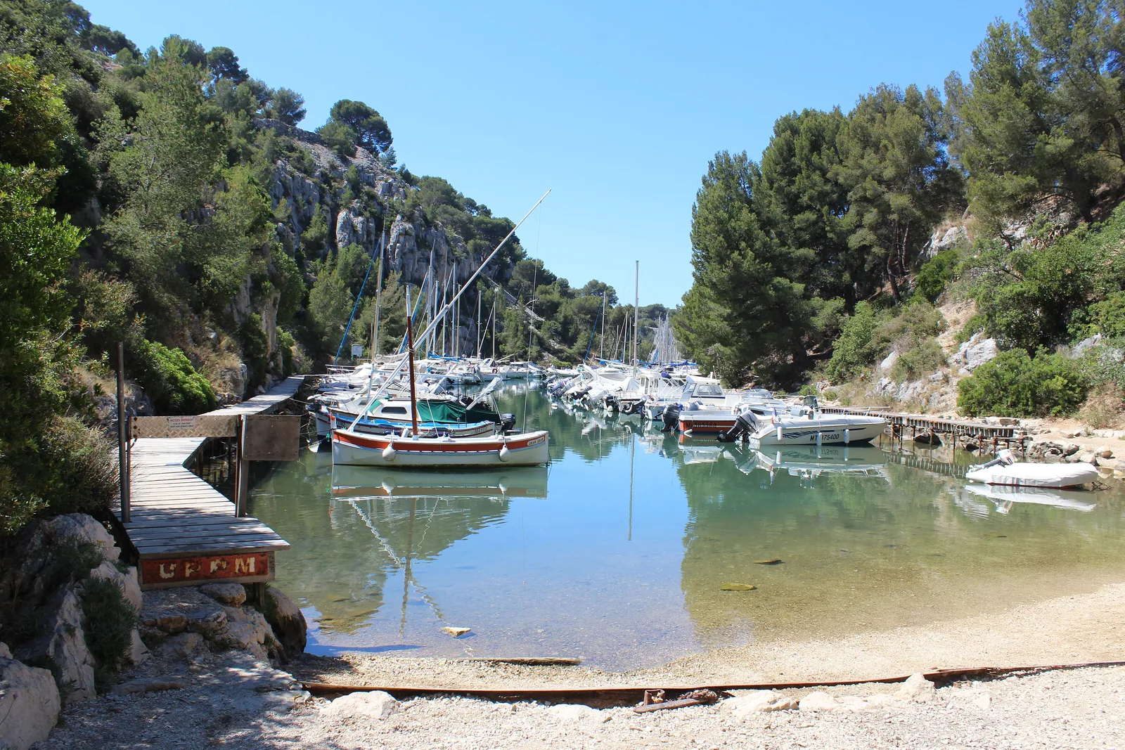
    1,400 m (4,593 ft) long, around 30 minutes from the centre of Cassis. Works until June 2027, detour via Port-Pin.

    Location source ↗
  • Plage de Port-Pin Beach

    Around 45 minutes from Cassis. According to the park, the descent is slippery and sharp-edged.

    Location source ↗
  • Belvédère d’En-Vau Viewpoint, 170 m (558 ft)

    View straight down into the calanque; around an hour’s walk down.

    Location source ↗
  • Calanque d’En-Vau Calanque

    The cove between vertical walls; landing by boat prohibited.

    Location source ↗
  • Plage d’En-Vau Beach at the end of the calanque

    No lifeguards, no water and no toilets; in summer up to 1,200 people at once.

    Location source ↗
  • Col de l’Oule Pass, 231 m (758 ft)

    The path from the Belvédère down into the Vallon d’En-Vau crosses this saddle.

    Location source ↗
  • Col de la Gardiole Pass, 259 m (850 ft)

    Access from the north; the road to the Gardiole is closed all year, so you park on the RD 559.

    Location source ↗
  1. Parc national des Calanques: Belvédère and Calanque d’En-Vau – access, landing ban, closures due to wildfire risk (French) ↗
  2. Parc national des Calanques: hike to the Calanque d’En-Vau via Port-Pin – 7.8 km (4.8 mi), 3 hours, 360 m (1,181 ft) (French) ↗
  3. Parc national des Calanques: notice – works at Port-Miou until June 2027, detour via Port-Pin, path closure (French) ↗
  4. Parc national des Calanques: Calanque de Port-Miou (French) ↗
  5. Parc national des Calanques: access during wildfire risk – closures on red days, 1 June to 30 September (French) ↗
  6. Bouches-du-Rhône prefecture: map of access to the massifs – daily closures due to wildfire risk, Massifs Calanques, Cap Canaille, Grand Caunet ↗
  7. Ville de Cassis: Gorguettes car park and shuttle to the Calanques – operating hours (French) ↗
  8. Office de Tourisme Cassis: getting there by train and bus (English) ↗
  9. GIE des Bateliers Cassidens: boat trips from Cassis, tours and duration (English) ↗
  10. Parc national des Calanques: swimming – only Sormiou and Saint-Estève have lifeguards (French) ↗
  11. Parc national des Calanques: before your visit – no water, no toilets, emergency number 112 (French) ↗
  12. Parc national des Calanques: park identity – founded 2012, 8,500 ha of land, 43,500 ha of sea, Mont Carpiagne 646 m (2,119 ft) (French) ↗
  13. Parc national des Calanques: FAQ – free entry, open 24 hours, dogs on a lead (French) ↗
  14. Parc national des Calanques: hike to the Calanque d’En-Vau via the Gardiole – 12.2 km (7.6 mi), 3 hours, 200 m (656 ft) (French) ↗
  15. Parc national des Calanques: Calanque de Port-Pin (French) ↗

How current is this information?

Researched 5 Oct 2026. Not a live status. Prices, timetables and opening hours change; please check with the operator before you travel.

Current information from the operator ↗

Image and map credits

Location sources: every point on the map links to the OpenStreetMap object its coordinate comes from. Markers do not imply that access is permitted.

End of the field book · Park authority ↗