National Parks Atlas
To the park
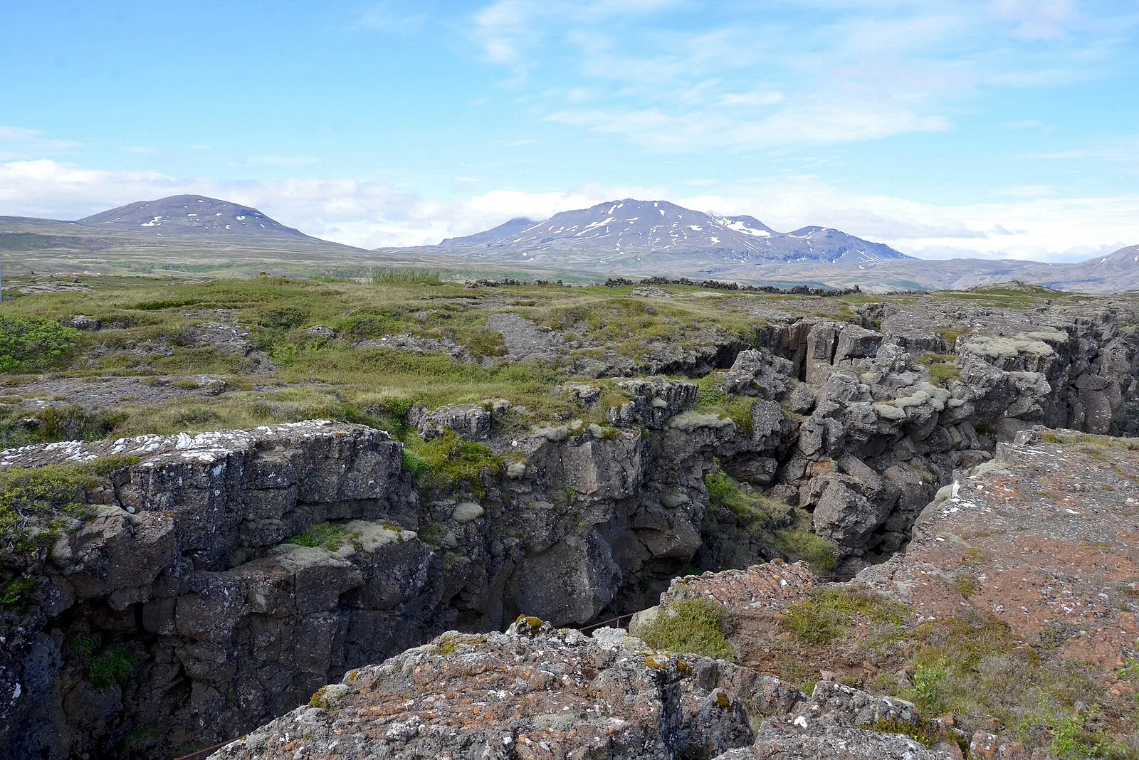
Almannagjá in Þingvellir National Park: a moss-covered fissure in the lava field, mountains with patches of snow behind

Þingvellir National Park: map

20 places with verified coordinates · 4 with photo

Bookable in the park · 5

Ad · partner links: we may earn a commission if you book – at no extra cost to you. Thank you for supporting the atlas. Offer details checked 4 Oct 2026; dates and prices with the provider.

Arrival · Visitor centre, “Heart of Iceland” exhibition

Hakið Visitor Centre (Gestastofa)

At the top of Almannagjá next to the viewing platform. April to October 9:00–18:00, November to March 9:00–17:00. At car park P1.

Own page

Silfra

Glacier water from Langjökull, filtered through lava for 30 years – and a fissure where you can see for 100 metres (328 ft).

Fee & rules

Tickets & entrance fees: what parking costs at Þingvellir

Exhibition ISK 1,200

The interactive “Heart of Iceland” exhibition in the visitor centre costs ISK 1,200, students and seniors ISK 600, children up to 17 nothing.

Þingvellir National Park: Hakið Visitor Centre – opening hours, exhibition ↗

Best time to visit: summer by the lake, winter in the snow

Visitor centre all year

April to October 9:00–18:00, November to March 9:00–17:00. Shorter hours apply between Christmas and New Year, on 24 December only 9:00–12:00.

Þingvellir National Park: Hakið Visitor Centre – opening hours, exhibition ↗

Open in OpenStreetMap ↗Location source ↗

64.25600, -21.12986

Arrival · Paid car park

Car park P1 Hakið

Parking fee by vehicle category, ISK 1,000 for a car; the ticket is also valid at P2 and P5 on the same day.

Tickets & entrance fees: what parking costs at Þingvellir

ISK 1,000 for a car

Cars with up to five seats pay ISK 1,000, six to nine seats ISK 1,200, motorcycles ISK 400. Buses pay ISK 2,200 to 4,200, depending on size.

Þingvellir National Park: Parking Service – parking fee by vehicle category ↗

Open in OpenStreetMap ↗Location source ↗

64.25538, -21.13163

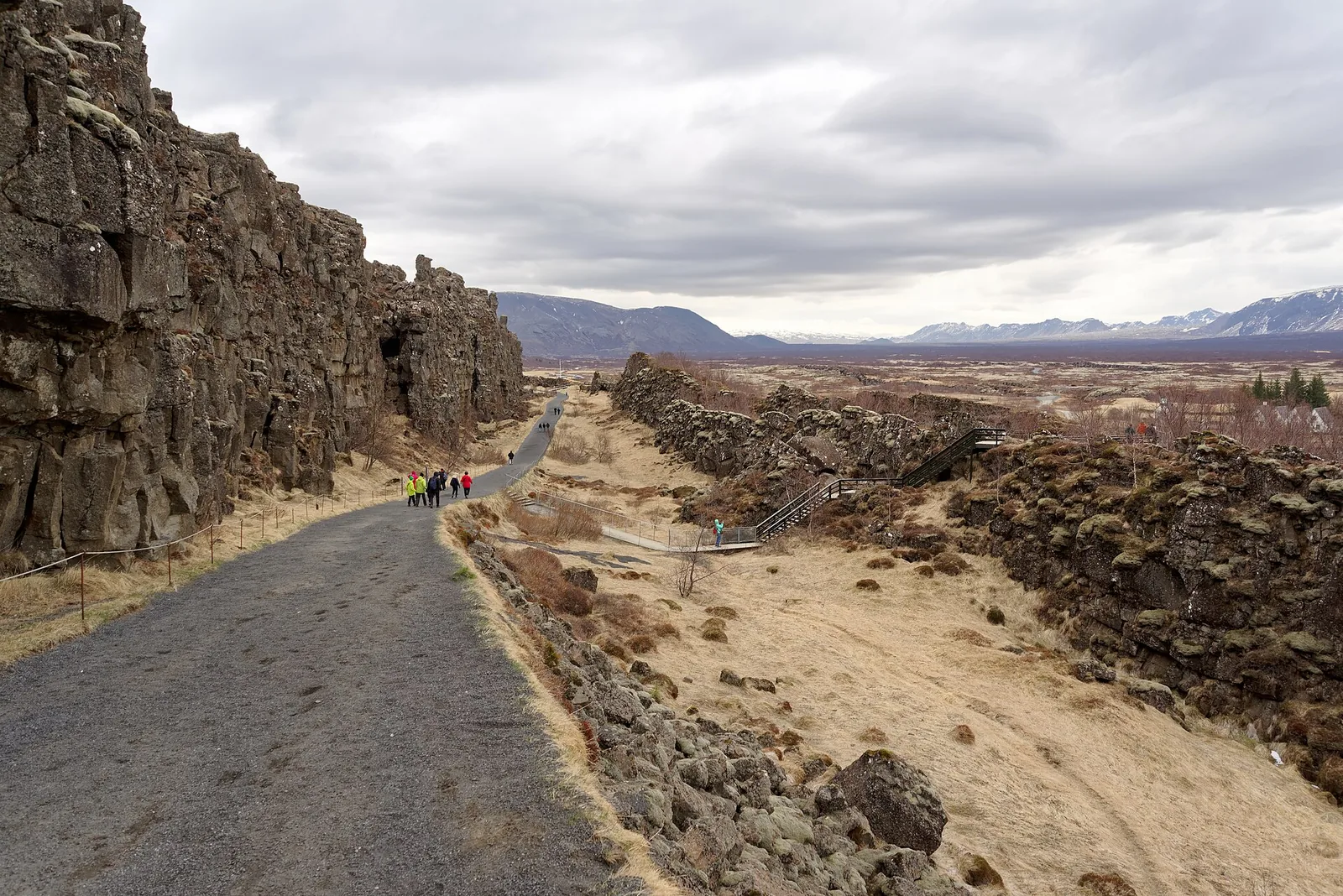
Path through Almannagjá in Þingvellir National Park: the high basalt wall on the left, the rift with dry grass on the right, visitors in the distance
Photo: Jakub Hałun ↗ · CC BY-SA 4.0 ↗

Trails · Rift gorge, path to the assembly site

Almannagjá

The western edge of the rift valley. From Hakið the path leads down through the gorge to Lögberg.

The western edge of the rift and the place where the Alþing met.

Alþing on site
about 930 to 1798
Commonwealth period
930–1262
Law Speaker's term
3 years
Subsidence since 930
almost 4 m (13 ft)
Independence declared
1944 at Lögberg

Hikes & tours: Almannagjá, Silfra, walking and fishing

Through Almannagjá to Lögberg

From the Hakið visitor centre the path leads down into the gorge to Lögberg and on to Öxarárfoss. According to the park, the paths at the assembly site are well signposted.

Þingvellir National Park: Hiking trails and riding routes ↗

Open in OpenStreetMap ↗Location source ↗

64.25854, -21.12471

Surroundings · Site of the assembly

Lögberg (Law Rock)

The Law Speaker recited the laws here. According to the park, its exact location cannot be determined with certainty.

Open in OpenStreetMap ↗Location source ↗

64.25954, -21.12254

Surroundings · Site of the legislative council

Lögrétta (1594–1798)

The Lögrétta was the highest body of the Alþing; it was moved because of flooding and subsidence.

Open in OpenStreetMap ↗Location source ↗

64.25961, -21.12183

Nature · Pool in the Öxará

Drekkingarhylur

A pool in the Öxará below Almannagjá, where the park has put up an information board.

Open in OpenStreetMap ↗Location source ↗

64.26105, -21.12185

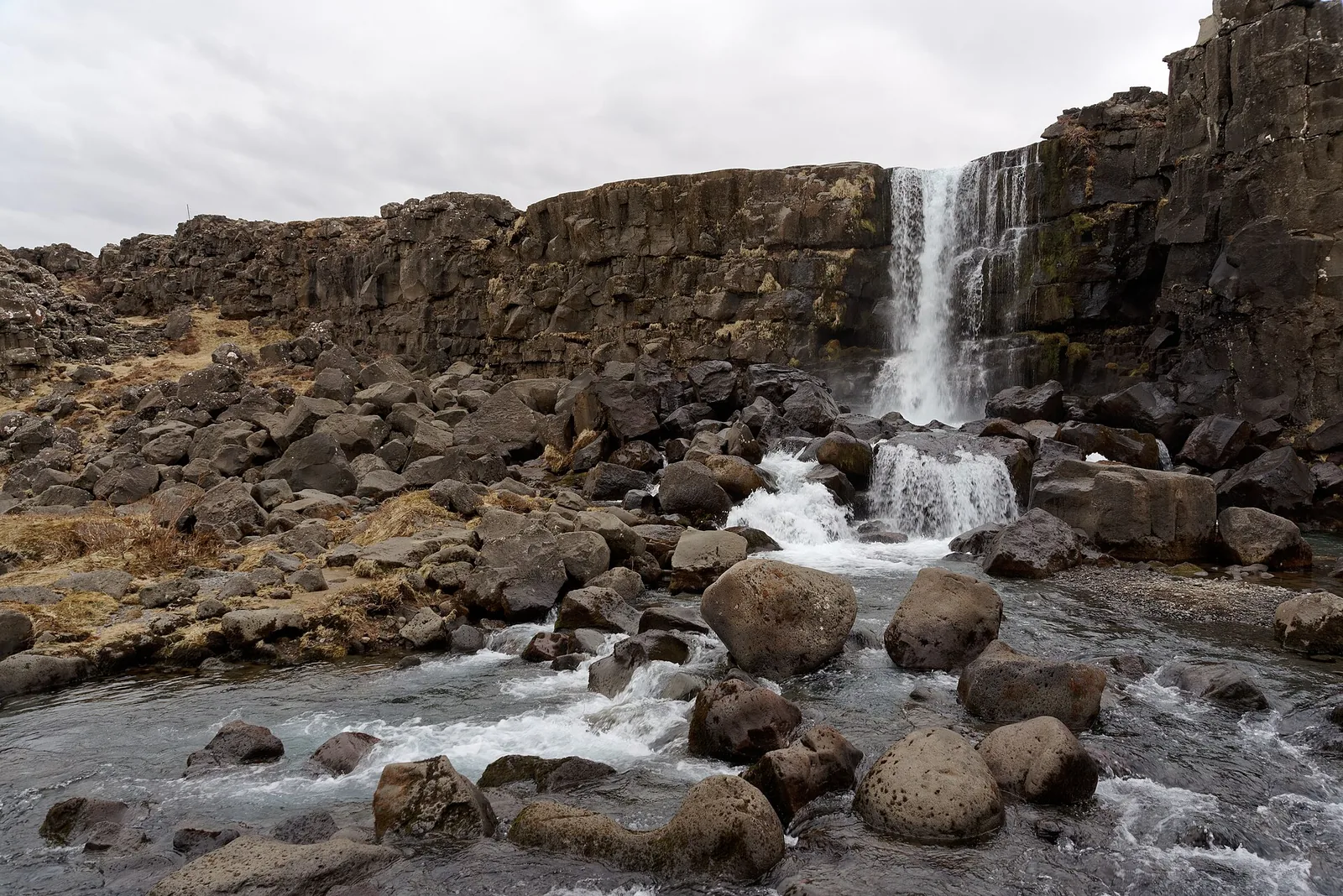
Öxarárfoss in Þingvellir National Park drops over a dark basalt edge into a pool full of round boulders
Photo: Jakub Hałun ↗ · CC BY-SA 4.0 ↗

Water · Waterfall

Öxarárfoss

The Öxará drops over the edge of Almannagjá here. The nearest car park is P2 Efri-Vellir below the falls.

The river said to have been diverted for the assembly.

River
Öxará
Nearest car park
P2 Efri-Vellir
Fishing in the Öxará
banned
Duels on Öxarárhólmi
until shortly after the year 1000

Open in OpenStreetMap ↗Location source ↗

64.26583, -21.11805

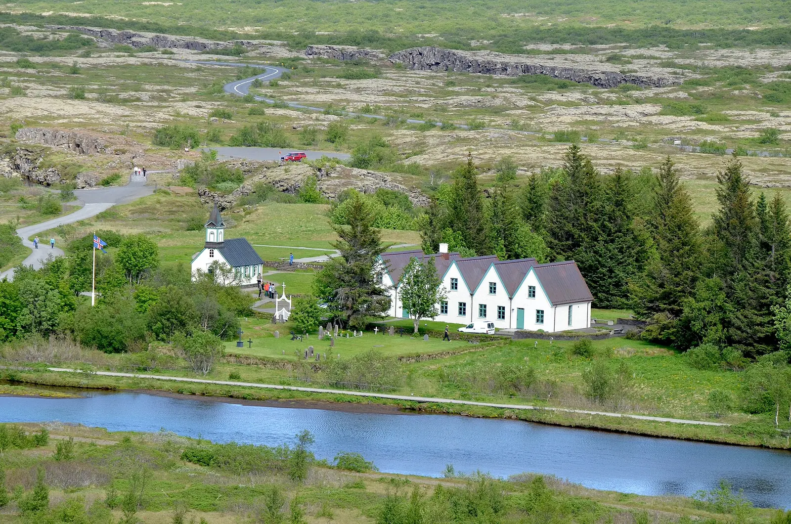
The white Þingvallakirkja and the gables of the Þingvallabær farmhouse in Þingvellir National Park, the Öxará in front, the lava plain behind
Photo: Olga Ernst ↗ · CC BY-SA 4.0 ↗

History · Church from 1859

Þingvallakirkja

Next to the Þingvallabær farmhouse, today the summer residence of Iceland's prime minister.

Church, farmhouse and the fissure full of coins.

Church built
1859
Þingvallabær farmhouse
oldest parts 1930
Bridge over Nikulásargjá
1907
Flosagjá, water depth
up to 25 m (82 ft)

Own page

Silfra

Glacier water from Langjökull, filtered through lava for 30 years – and a fissure where you can see for 100 metres (328 ft).

Fee & rules

Open in OpenStreetMap ↗Location source ↗

64.25741, -21.12109

Nature · Fissure with coins

Peningagjá

Part of Flosagjá. Since a bridge was built there in 1907, visitors have thrown coins into the water.

Own page

Silfra

Glacier water from Langjökull, filtered through lava for 30 years – and a fissure where you can see for 100 metres (328 ft).

Fee & rules

Open in OpenStreetMap ↗Location source ↗

64.25840, -21.11716

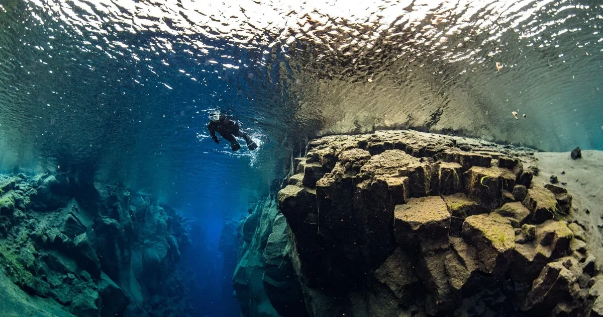
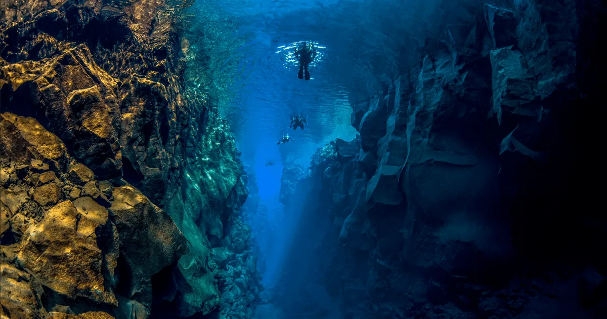
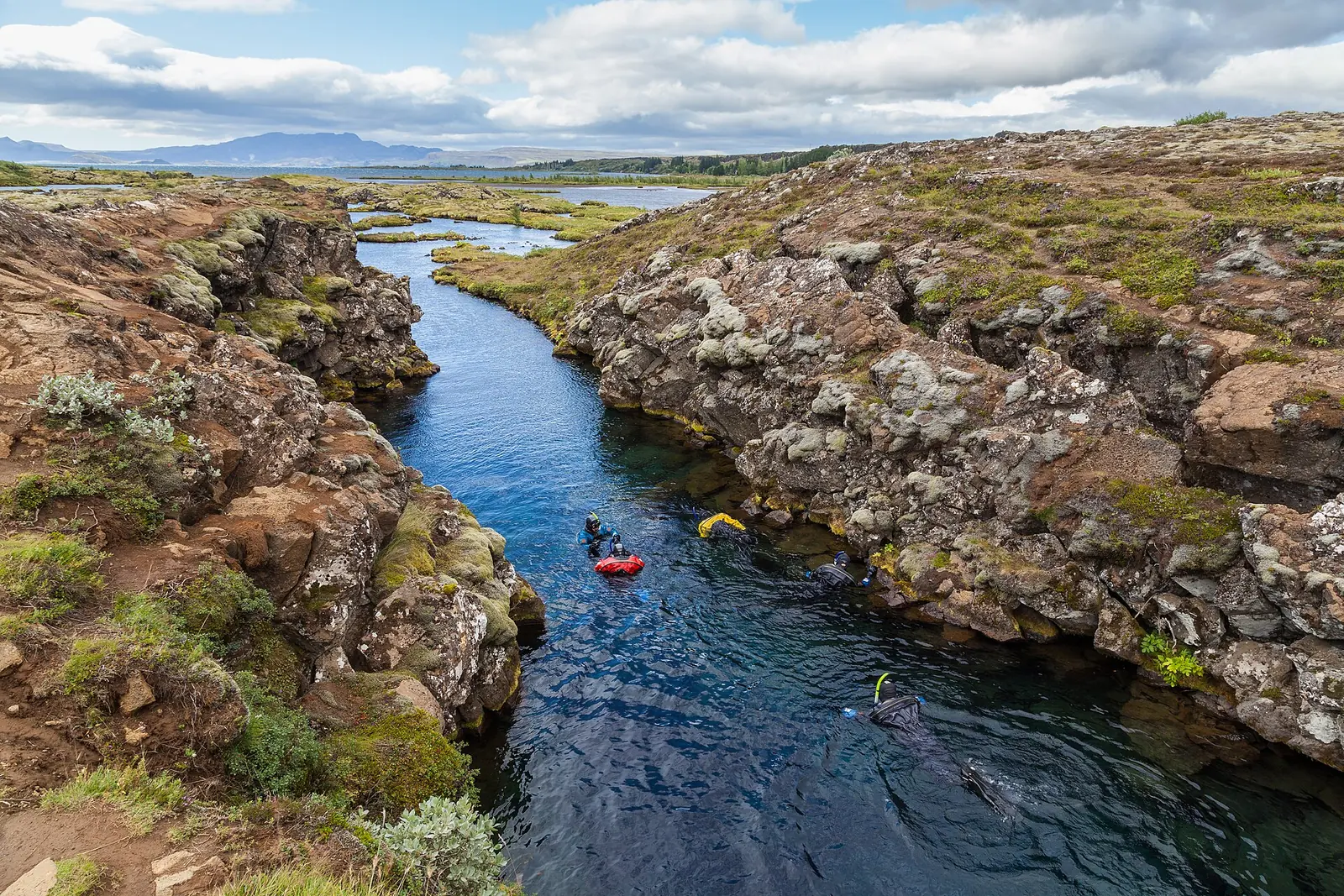
Snorkellers in the Silfra fissure in Þingvellir National Park drift through clear blue water between moss-covered lava rocks
Photo: Diego Delso ↗ · CC BY-SA 4.0 ↗

Nature · Fissure for diving and snorkelling

Silfra

Up to 10 m (33 ft) wide and up to 60 m (197 ft) deep. Only with a permit and a buddy, no deeper than 18 m (59 ft); ISK 1,500 fee per dive.

The clearest fissure in the park – entered only with a permit, in a dry suit.

Width
up to 10 m (33 ft)
Depth
up to 60 m (197 ft)
Visibility
about 100 m (328 ft)
Water temperature
2–4 °C (36–39 °F)
Permitted diving depth
18 m (59 ft) maximum
Fee per dive
ISK 1,500

Own page

Silfra

Glacier water from Langjökull, filtered through lava for 30 years – and a fissure where you can see for 100 metres (328 ft).

Fees at Silfra, as of 4 Oct 2026
Diving, snorkelling or freediving, per diveISK 1,500
Parking P5 Valhöll, car up to 5 seats, per dayISK 1,000
Parking, car 6 to 9 seatsISK 1,200

Fee & rules

Best time to visit: summer by the lake, winter in the snow

Silfra all year round

According to the park, the fissure draws thousands of divers and snorkellers all year. The water is 2 to 4 °C (36–39 °F).

Þingvellir National Park: Silfra – geology and history ↗

Rules & safety: fissures, drones, Silfra

Never Silfra alone

Diving and snorkelling only in pairs, no deeper than 18 m (59 ft), no caves. Divers need a diving licence and a dry suit certificate or ten dry suit dives in two years.

Þingvellir National Park: Diving – rules for diving and snorkelling ↗

Hikes & tours: Almannagjá, Silfra, walking and fishing

Snorkelling in Silfra

According to the park, Silfra is one of the best dive sites in Iceland, with visibility of about 100 m (328 ft). The park does not provide equipment; tour operators bring dry suits.

Þingvellir National Park: Köfun – conditions and legal basis for diving (Icelandic) ↗

Nature: plates, fissures and a lake full of char

Water 30 years on the way

Silfra's water comes from Langjökull and seeps through the lava for about 30 years before it emerges. That is why visibility reaches about 100 m (328 ft).

Þingvellir National Park: Silfra – geology and history ↗

Guided from here · Ad

Partner links: we may earn a commission if you book – at no extra cost to you. Thank you for supporting the atlas. Dates and prices with the provider.

Open in OpenStreetMap ↗Location source ↗

64.25519, -21.11694

Arrival · Paid car park

Car park P5 Valhöll

The closest car park to the church and to Silfra; snorkelling guests park here too.

Own page

Silfra

Glacier water from Langjökull, filtered through lava for 30 years – and a fissure where you can see for 100 metres (328 ft).

Fee & rules

How to get there from Reykjavík: Road 36 or a Golden Circle tour

Where to park

P1 at the Hakið visitor centre for Almannagjá, P2 below Öxarárfoss, P5 Valhöll for the church and Silfra. All three charge a fee; one ticket is valid for all.

Þingvellir National Park: Parking Service – parking fee by vehicle category ↗

Open in OpenStreetMap ↗Location source ↗

64.25552, -21.12433

Arrival · Information, café, permits

Leirar Service Centre

At the junction of roads 36, 361 and 52. Permits for camping, fishing and diving in Silfra are sold here.

Own page

Silfra

Glacier water from Langjökull, filtered through lava for 30 years – and a fissure where you can see for 100 metres (328 ft).

Fee & rules

How to get there from Reykjavík: Road 36 or a Golden Circle tour

49 km on Road 36

According to UNESCO the park lies 49 km (30 mi) east of Reykjavík. The Leirar service centre stands at the junction of roads 36, 361 and 52.

Þingvellir National Park: Camping – sites, seasons, prices, rules of conduct ↗

Where to stay: four campsites at Leirar and by the lake

No check-in needed

You choose a spot yourself. If you arrive outside opening hours, you pay online or at the service centre the next morning. Quiet hours 23:00 to 8:00.

Þingvellir National Park: Camping – sites, seasons, prices, rules of conduct ↗

Open in OpenStreetMap ↗Location source ↗

64.27986, -21.08806

Where to stay · Campsite, open all year

Nyrðri-Leirar campsite

The only campsite in the park open all year, with electric hook-ups for motorhomes.

Best time to visit: summer by the lake, winter in the snow

Camping from 1 June to 15 September

All four sites are open during this period. From 16 September to 31 May only Nyrðri-Leirar stays open.

Þingvellir National Park: Camping – sites, seasons, prices, rules of conduct ↗

Where to stay: four campsites at Leirar and by the lake

ISK 1,800 per night

Adults aged 18 to 66 pay ISK 1,800, seniors and disabled visitors ISK 900, children up to 17 nothing. Electricity for motorhomes ISK 1,100 for 24 hours.

Þingvellir National Park: Camping – sites, seasons, prices, rules of conduct ↗

Open in OpenStreetMap ↗Location source ↗

64.28030, -21.08496

Where to stay · Tent site, summer

Fagrabrekka campsite

Tents only, 1 June to 15 September. A footpath leads to Þingvellir in about 30 minutes.

Open in OpenStreetMap ↗Location source ↗

64.27684, -21.09583

Where to stay · Abandoned farm, tent site, fishing spot

Vatnskot

On the shore of Þingvallavatn, about five kilometres (3 mi) south of Leirar. A tent site in summer and the most popular fishing spot in the park.

Hikes & tours: Almannagjá, Silfra, walking and fishing

Fishing for ISK 2,500 a day

On the northern shore of Þingvallavatn between Leirutá and Langitangi, from the shore only. Children accompanied by an adult with a permit fish for free. Used equipment from abroad must be disinfected.

Þingvellir National Park: Angling – season, permit, closed areas ↗

Where to stay: four campsites at Leirar and by the lake

Tents only at Fagrabrekka and Vatnskot

Both sites are open from 1 June to 15 September and for tents only. Vatnskot is five kilometres (3 mi) south on the lake shore.

Þingvellir National Park: Camping – sites, seasons, prices, rules of conduct ↗

Open in OpenStreetMap ↗Location source ↗

64.24433, -21.08806

History · Ruins of a farm

Skógarkot

An abandoned farm in the middle of the rift valley and the goal of a popular walk.

Hikes & tours: Almannagjá, Silfra, walking and fishing

Walks to abandoned farms

Away from the assembly site, most paths lead to the abandoned farms of Hrauntún, Skógarkot and Vatnskot. Maps are available as PDF on the park's website.

Þingvellir National Park: Hiking trails and riding routes ↗

Open in OpenStreetMap ↗Location source ↗

64.26231, -21.07108

Nature · Eastern edge of the rift

Hrafnagjá viewing platform

On Hrafnagjá, the eastern fissure of the rift valley. Between Almannagjá and Hrafnagjá the land has subsided.

Þingvellir National Park: where Iceland founded its parliament

A rift that keeps widening

Þingvellir lies in a rift valley about seven kilometres (4 mi) wide between Almannagjá and Heiðargjá. Since the lava flow 10,000 years ago the land has sunk about 40 m (131 ft) and been pulled apart by 70 m (230 ft).

Þingvellir National Park: Tectonic Movements ↗

Open in OpenStreetMap ↗Location source ↗

64.24703, -21.02578

Nature · Second diving fissure

Davíðsgjá

The second fissure where diving is allowed. It lies in the lake; you have to swim some distance.

Own page

Silfra

Glacier water from Langjökull, filtered through lava for 30 years – and a fissure where you can see for 100 metres (328 ft).

Fee & rules

Open in OpenStreetMap ↗Location source ↗

64.23930, -21.04732

Mountains & rock · Mountain in the north of the park

Ármannsfell

Mountain on the northern edge of the park, still inside according to the OpenStreetMap boundary.

Open in OpenStreetMap ↗Location source ↗

64.32657, -21.03260

Locations verified from the linked original sources and OpenStreetMap. The map shows no trails or park boundaries; markers do not imply that access is permitted.

Map: © OpenStreetMap contributors, OpenMapTiles, OpenFreeMap. Elevation: Terrain Tiles (Mapzen, AWS Open Data); 3DEP, GMTED2010 and SRTM courtesy of the U.S. Geological Survey; EU-DEM (Copernicus, European Union); ETOPO1 (NOAA); ArcticDEM (NSF, DigitalGlobe); Geoscience Australia; Open Data Austria (DGM); Open Government Licence – Canada; INEGI; Land Information New Zealand; Kartverket; Environment Agency (UK).

Park photo: Photo: Olga Ernst ↗ · CC BY-SA 4.0 ↗

Loading map …